Scan4Model

BIM Modeling Services

Accurate and reliable models for more confident decision-making.

We transform real-world data into detailed and consistent BIM models tailored to each phase of the project. We ensure accurate geometries, levels of detail adapted to your needs, and a solid digital foundation to improve coordination, planning and control.

BIM Modeling

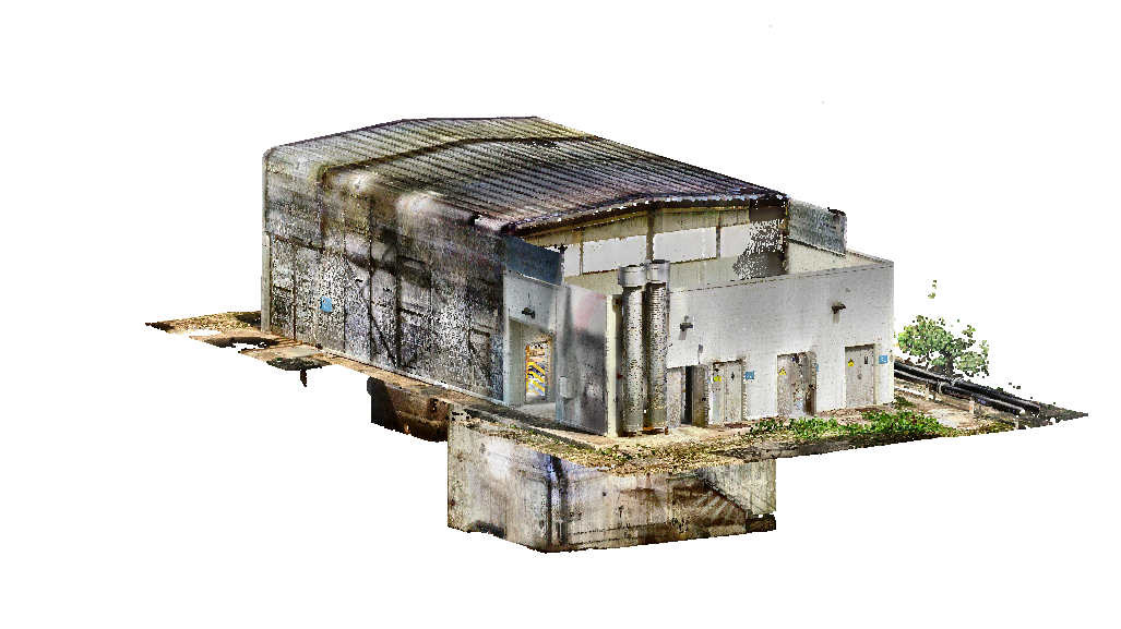
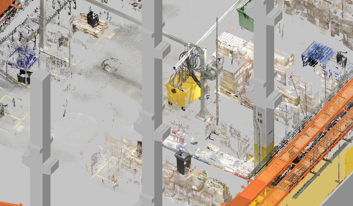
Reality capture data can be used within a collaborative BIM environment.
 
BIM models can be generated from data collected on site, and construction progress can also be monitored by comparing the measured reality against the theoretical model or design.

Benefits of BIM Modeling

1. Digitalization

We digitize physical environments through 3D scanning and advanced reality capture technologies, obtaining accurate and up-to-date data. This provides a reliable foundation that reduces errors and speeds up decision-making.

2. Information Interoperability

We create BIM models compatible with multiple software platforms and workflows, facilitating seamless data exchange. Information flows smoothly between teams, improving project coordination and efficiency.

3. Progress Monitoring and Issue Management

We deliver models that enable construction progress tracking and the identification of deviations in real time. This improves issue management and helps keep projects under control.

4. Virtual Tours

We create immersive virtual tours that allow spaces to be explored remotely. These tours enhance project understanding and accelerate validation by clients and technical teams.

Services Using BIM Methodology

+20 YEARS OF EXPERIENCE

With more than 20 years of experience through Metromecánica, we have evolved from our beginnings in industrial metrology to become a benchmark in AEC digitalization.

servicio de modelado bim

Industries We Serve

Architecture and Construction (AEC)

We empower your projects with clear BIM models, accurate 3D scans, and virtual tours that make it easier to sell, coordinate, and execute successfully. We reduce unforeseen issues and accelerate decision-making from day one.

Industry and Manufacturing

We digitize industrial facilities so you can plan expansions, optimize processes, and maintain assets with confidence. Metromecánica’s expertise ensures reliable results even in the most demanding environments.

Infrastructure and Civil Engineering

We provide accurate and up-to-date data on roads, tunnels, utility networks, and major civil engineering projects. Using laser scanning, SLAM technology, and drones, we capture the information you need to design, monitor, and optimize your infrastructure.

Aerospace and Energy

We bring precision and reliability to industries where there is no room for error. Our advanced equipment and international certifications ensure accurate measurements and dependable models that support high-impact decision-making.

What is BIM Modeling?

 
BIM Modeling is a collaborative working methodology based on the creation of a centralized model where all stakeholders contribute and manage the information related to a project. This digital model brings together geometry, technical data, project phases, costs, and documentation, enabling everyone to work from a single source of truth. The result is a more coordinated, transparent, and efficient process, from the initial design stage through to asset operation.
 
Beyond being a three-dimensional representation, BIM integrates key information that facilitates early error detection, accurate construction planning, and intelligent maintenance management. As a result, teams reduce time, costs, and risks while increasing the reliability of their decision-making. BIM not only improves how projects are designed and built, but also how buildings and infrastructure are managed throughout their entire lifecycle.
 
In sectors such as architecture, engineering, construction, and industry, BIM Modeling has become an essential standard. It enables teams to work with accurate data, coordinate disciplines, and optimize communication between all stakeholders, driving more sustainable, cost-effective, and safer projects.
servicio modelado bim

Phases of the BIM Modeling Service

Every project and every client is unique. That is why we tailor our services to respond as accurately as possible to their specific needs. Nevertheless, our typical workflow is generally structured around the following phases.

BIM Modeling

1. Client Consultation

An initial discussion to understand the client’s requirements, review the project specifications, define service timelines, and provide an estimated delivery schedule.

2. Site Visit

We carry out a guided site visit to refine the strategy, logistics, and work schedule. This allows us to fine-tune initial assumptions and ensure accurate traceability throughout the project.

3. Scanning Preparation and Strategy

Based on the information gathered on-site, we develop an action plan backed by our experience. We coordinate different technologies, including LiDAR, SLAM, GPS, photogrammetry, and drones, according to the complexity of the project.

4. Data Capture

We perform the data acquisition process using specialized equipment, minimizing disruption to the client’s operations and adapting to their schedule to avoid interruptions.

5. Data Processing

We align and process the captured scans to generate an accurate point cloud that will serve as the foundation for the final deliverables.

6. Post-Processing and Deliverables 

Using the point cloud as a basis, we produce the required outputs, including discipline-specific BIM models, flatness analyses, issue detection, meshes, 2D drawings, detailed geometric documentation, as-built models, measurements, virtual tours, and object-level digitalization, among others.

FREQUENTLY ASKED QUESTIONS ABOUT BIM MODELING

What do I need to provide for you to generate a BIM model?

We only require the project data that is already available: existing drawings, point clouds, photographs, Level of Detail (LOD) requirements, and any relevant technical specifications. Once the project has been reviewed, we will determine whether additional data capture is required to obtain an updated point cloud.
 
The best way to obtain a reliable BIM model is from an up-to-date point cloud of the area of interest. At Scan4Model, we specialize in acquiring high-quality, highly accurate point clouds tailored to the specific requirements of each project. If the client already has an existing point cloud, we can assess its suitability for producing a BIM model that meets the project’s needs.

What Level of Detail (LOD) can you deliver?

We work with Levels of Detail ranging from LOD 100 to LOD 500, depending on the client’s requirements. We adjust geometric accuracy, embedded information, and the level of definition to suit applications such as new construction, renovations, project supervision, maintenance, and final As-Built documentation.

What software is your BIM modeling compatible with?

We create fully interoperable models compatible with industry-leading platforms such as Revit, Navisworks, Archicad, and others. We can also deliver models in the standard IFC format to ensure seamless data interoperability between all project stakeholders. This allows for easy integration into different workflows and multidisciplinary teams.

How long does a BIM modeling project take from data delivery?

The delivery time depends on the size of the project, the complexity of the asset, and the required level of detail. As a general reference, medium-sized projects are typically completed within 1 to 3 weeks. After reviewing your initial information, we provide a precise estimate and a defined project schedule.
 

How do you ensure the accuracy of the BIM model?

We start with high-quality point clouds and apply internal verification processes at every stage of the modeling workflow. In addition, we perform cross-checks against the original geometry and deliver the project with validation reports that certify the consistency and accuracy of the model.

Contact us with no obligation.

We would be delighted to learn more about your project.

Error: Contact form not found.